Russian BIM: from theory to practice
 Vladimir Frolov Head of Transport Infrastructure Department, Stroyproekt-INFO LLC
Industry experts have been talking about the need for widespread introduction of digital modeling in the design and construction of infrastructure facilities for several years. However, the application of BIM technologies (Building Information Modeling) faces serious restrictions, both regulatory and technical.
In particular, existing software is mainly focused on industrial and civil engineering and is often inapplicable to transport. To fill the gaps in this area, St. Petersburg specialists have developed their own software. It greatly facilitates the work with digital models, which opens the way for wide application in the industry.
Specialists from the S-INFO company: Igor Rogachev, Stanislav Volodchenko and Vladimir Frolov told the correspondent of our magazine about their development.
I have been working on the topic of BIM for transport infrastructure for the last ten years, and during this time I have worked with various software. Every time I came across certain limitations and difficulties with functionality. One of the main reasons for this is that all BIM programs are focused on industrial and civil engineering (ICE) and do not take into account the specifics of designing transport infrastructure facilities.
Let me explain. The PGS object is a point object, it occupies a small area, therefore its digital model will also be compact, significantly inferior in data volume to models of road construction objects - highways, the length of which is tens or even hundreds of kilometers, containing many artificial structures, engineering networks and arrangement elements. Since modern software is not designed to work with such a volume of data, it does not allow for the effective implementation of all tasks in the design process.
The next point is related to information security, primarily with data storage requirements. Foreign developers actively use cloud services, while the servers where information is stored are located mainly in Western Europe or North America. We must not forget that any road is a strategic object. This imposes a restriction on storing project documentation abroad. Moreover, the ban on the use of cloud services is normatively enshrined in many Russian state-owned companies.
To use a digital model, you need expensive software, as well as competent specialists who can work with the resulting information model. It is worth noting the staff shortage in this area. There are, of course, free programs for viewing models, but their functionality is very limited. For example, you cannot exchange messages, link documents and links to the finished model, and the model itself must be located on the local computer.
These factors impose serious restrictions on the use of BIM technologies in transport construction. And we are talking not only about the design process - modeling itself, but also about the further use of digital models. All this was the reason for creating our own solution that would fully meet the challenges facing customers, designers, builders and operating organizations.
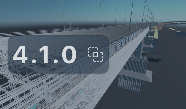
It all started about five years ago. As a pilot project, we created a digital model of the WHSD section, which was intended for more efficient operation of the highway. At that time, a kernel developed in the USA was used to solve this problem. Then, based on our experience and understanding of what the infrastructure BIM market needed, we developed the first version of our own software. The product was simply named “S-INFO v.1.0”. Initially, the software package provided solutions to problems only for working with single artificial structures. The speed and functionality were sufficient for this. But then, when extended objects began to work, it became clear that the original version had a number of limitations. In particular, insufficient coordinate accuracy created difficulties for positioning objects in the model. We were able to adapt the software to new tasks.
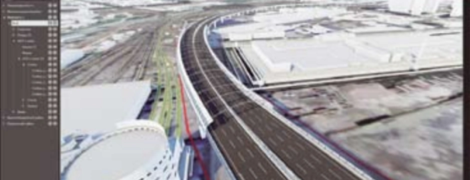
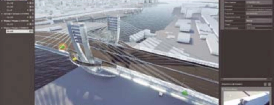
By the end of summer we plan to release a full version of “S-INFO v.2.0”. The new engine, developed in the Russian Federation, allows you to work with larger-scale digital models. And these are not only long road facilities with a large number of artificial structures. The resolution allows you to work with models at the scale of cities and entire regions; the binding is based on geographic coordinates. We loaded a digital model of St. Petersburg into our software, on which we located the objects designed in recent years and those being designed today. In particular, the Betancourt Bridge, sections of the WHSD and the Shirotnaya Expressway with a bridge across the Neva River at the alignment of the street. Fayansovaya - st. Ash is the so-called Eastern High Speed Diameter (VSD).
I would like to note that the process of developing and improving our software continues; we are constantly expanding its functionality, focusing on the needs of all organizations involved in the life cycle of road facilities: from the customer to the operating organization.
As a result, we received a convenient tool for working with a ready-made information model. Moreover, it does not matter in what environment it was modeled or designed. It should be noted that our solution allows you to combine engineering data and demonstration capabilities in one product.
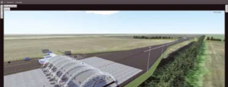
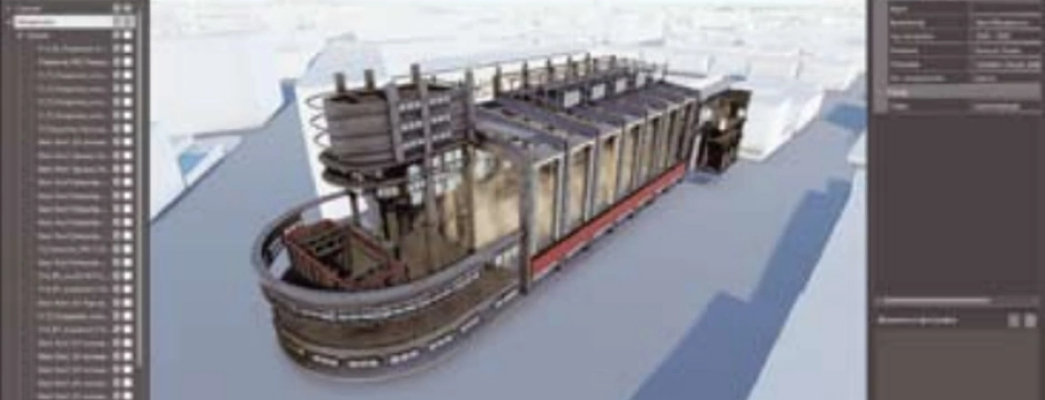
I'll tell you what it looks like. On the screen we see a three-dimensional image of the object linked to the surrounding landscape. But this is not just a visualized project presented in volume, but a full-fledged engineering model that fully complies with the design documentation. If necessary, we can consider each of the design elements in detail. There is also customizable functionality for specialized tasks of infrastructure design, pre-design survey, construction, designer supervision and operation.
Files are associated with each element. Depending on the stage of implementation and the tasks set by the customer, you can link drawings, as-built documentation, certificates of completion, data on the presence of defects and their images - that is, a full range of documents describing the history of the project.
The peculiarity of this model is that it can be viewed on a regular computer. This does not require any special software or even installation. The model is placed on a regular removable drive, which is transferred to the customer, while the interface is as convenient and intuitive as possible for the user. In addition, there is a client-server version with remote access, which can be used both on a personal computer and via the Internet on a regular tablet.
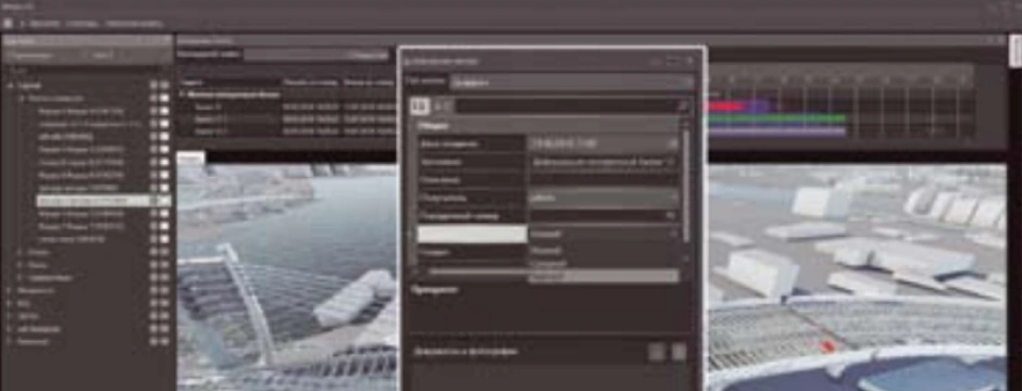
The information model can be used by all project participants: customers, designers, builders, construction control and architectural supervision engineers, operating organizations. At the design stage, thanks to such a model, it becomes possible to visually familiarize yourself with the project and eliminate collisions. At the construction stage, the model will show a complete picture of the process and help make management decisions in a timely manner, and at the operation stage it will allow you to have at hand the entire history of the object, making it possible to note its current condition and identified defects. Multifunctionality and a simple interface maximize the range of potential users and areas of application of information modeling.
A recent example relates to the design of high-pressure motors. In mid-July 2018, we were invited to the administration of the Krasnogvardeisky district of St. Petersburg to coordinate the routing of the highway. Since this issue is quite acute, instead of drawings, we took a digital model, which allowed us to visualize how the route would go, where the houses would be located, and what territory the construction sites would occupy. There we also took into account the future development of the railway. Using this model, we showed that VSD will bring positive changes and help solve many transport problems in the city.
I would like to note that the model we demonstrated fully correlates with the results of the current stage of highway design and includes all engineering information. As a result, we were asked to provide a model for public hearings and show it to people.
There is another example. At the end of last year, we had to submit an information model to the government customer. One of the requirements is to provide multi-user access to the model via the Internet, and at the same time, the location of the data and server on the territory of the Russian Federation. In this regard, our company’s specialists developed an information model in our software for the customer, and deployed the server at our facilities. Upon completion of work, it can be transferred to the customer’s computing resources.
As mentioned above, we have two architectural solutions. In the first case, the information model and database are located on a removable storage device. This approach allows you to transfer reporting materials to the customer directly with the information model of the structure and does not require any additional software from the customer, or even installation of the program. In addition, such a model can be used for demonstration purposes.
The BIM ideology assumes that all users work with the same database and have access to common updated information. Hence the need arises to develop a convenient and visual interface for access to the shared data environment for all participants in the process.
The second option is client-server software execution. This is a distributed system that allows you to collect information from all participants in the design, construction, and operation processes and provide controlled access to it. In addition to the classic desktop solution, mobile and web access to the model is possible.
The undeniable advantage of this solution is the possibility of locating the server anywhere, including on the custome's premises, while almost all such foreign platforms provide storage of information on servers outside the Russian Federation. Thus, with the help of our software, maximum information security is achieved, including physical safety of data.
In addition, you can use the “server - thin client” scheme. The server stores databases and file documents linked to model elements. The server generates web content and sends it to mobile or desktop devices. That is, to use the web model, it is not necessary to install software; a regular browser is enough. In this case, the processing of 3D models and the association of data with their elements occurs directly on the server, which reduces the load on client applications, but at the same time client machines can only gain limited access to the central program.
To ensure confidentiality and safety of information, a special role model has been developed, which allows flexible settings for access to information and software functions. The user, depending on his role, may have limited access to data and visibility of individual model elements.
The rather powerful graphics engine for the “desktop” client deserves special attention.
Typically, products aimed at engineers today have very little visual content. To increase productivity, all elements are made schematically, and in order to make a demonstration model, it is necessary to resort to the help of third-party software. Our engine allows you to work immediately on a realistic model. This opens up new horizons in terms of using the capabilities of virtual reality.
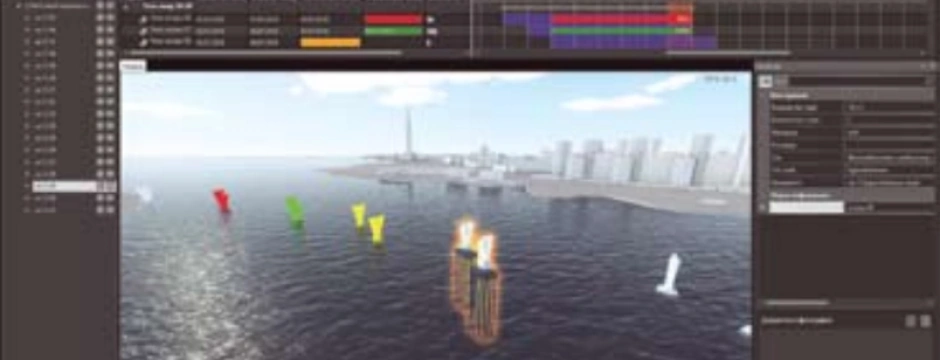
The second advantage of the system's graphics engine is the ability to work with large spaces, which is important for linear transport infrastructure objects. The engine supports visualization of a space of 1000 x 1000 km in size with a high level of model detail, sufficient, for example, for operational purposes (usually the basic level of detail of information models is LOD350).
The graphics engine allows you to work in real coordinates, which are used when designing an object, or in city coordinates, if we are making a model of the entire city. Double precision of coordinates makes it easy to position on stage assembly models consisting of different parts (often made in different engineering software systems and coming from different performers). The use of real coordinates (or instant transition to them from design coordinates) allows you to track the location of client mobile devices directly on the model, and also opens up opportunities for construction management in terms of tracking machines and mechanisms in real time.
Our goal was to create a unified BIM platform for transport infrastructure facilities, that is, great integration opportunities were laid out from the very beginning. In fact, our platform has the ability to integrate with any open source data system (or interfaces for accessing data). This can be a customer's management and planning system or a system for monitoring and tracking the condition of artificial structures. In our practice, there have already been cases of integration with traditional 1C systems, we have considered the possibilities of integration with Oracle Primavera, and we are considering the possibility of obtaining data from the planning system for the construction of Spider Project.
To date, we have already gained considerable experience. Among the most significant projects, it is worth mentioning a detailed model of the Betancourt Bridge. Now, as already noted, we are working closely on VSD. We designed and created information models for two more large transport facilities.
With each completed project, the advantages provided by the use of BIM technologies become obvious. First of all, interest is shown by large contractors who, through this technology, strive to make their work more efficient. Some experience has been gained in this direction.
I would like to note that our Italian colleagues were also interested in our solution. They have nothing like this, and now we are negotiating about joint participation in competitions, despite certain restrictions that we have encountered. I hope that we will find a way out of this situation and adequately present Russian developments on the foreign market.
This year we plan to use the BIM model during the construction phase. We are faced with the task of ensuring management of construction processes. Scheduling, plan-fact analysis, monitoring the volume of work performed on a construction site, recording emerging problems - the implementation of these and other tasks will optimize construction through the use of an information model. And for the customer, this is an opportunity to get the whole picture of the construction work with the possibility of detailed detailing, right down to the condition of a specific support.
In addition to operational management, the model allows you to accumulate the entire volume of design, working and as-built documentation, saving it for the entire life of the facility with reference to a specific element, which makes it easier to find the necessary information. Thus, a comprehensive history of the structure is formed.
The lack of standards, of course, significantly slows down the process of technology implementation. The concept of information modeling at transport infrastructure facilities still has a weak legal status, and the government customer simply cannot require the presence of BIM in the technical specifications.
The need for regulatory documents is very urgent. The specificity of rule-making here is that there are no BIM standards for infrastructure not only in Russia, but throughout the world. It is worth recognizing that this topic is being dealt with quite thoroughly in our country, and we are actively participating in the process, acting as experts in working groups.
Last fall, at the request of Rosavtodor, we carried out research work on the use of BIM technologies on pilot projects. Reviewers of this research work were about 30 organizations: designers, vendors who produce CAD systems for design, government customers. We received very good feedback. Developments on this topic have been assigned ODM status by Rosavtodor (No. 218.3.105-2018).
The need for large-scale application of information modeling is obvious. These issues are being dealt with by the specialized technical committee under the Ministry of Construction, amendments to the Urban Planning Code are being considered in the State Duma, and the topic is being studied in Rosavtodor. It is noteworthy that with such work we are laying the basis for the further existence of technology in the country.
These processes will be reflected in our product. We don't just keep our finger on the pulse, but we build into the software those opportunities for standardization and collaboration that will arise later. For example, we take into account the possibility of working with the open IFC format, which will be standardized in Russia in the future.
The program is constantly evolving. It introduces additional functions due to new tasks facing users. We control this process and develop our software taking into account the needs of tomorrow. This is the only way to maintain leadership positions.
Vladimir Frolov Head of Transport Infrastructure Department, Stroyproekt-INFO LLC